Friday, November 18, 2011

Jordanian Mosaics

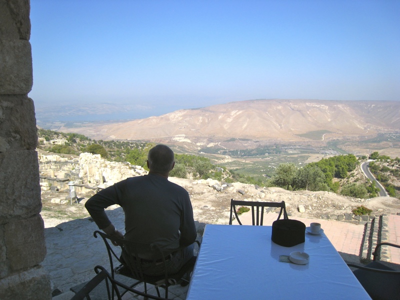
The next morning, we stopped again at Madaba to spend some time at the other churches inside the archaeological park. The open-air park also features a section of the city's ancient Roman road, as well as mosaics culled from other nearby towns. My dad is examining one of those in the photo above.

Above, the 6th century Byzantine "Hippolytus Hall" (part of a wealthy Roman house) with the adjoining Church of the Virgin behind it.

To the left, you can see four birds around a circle, which features a depiction of two sandals. This was the entrance to the room and indicated that you were to leave your shoes here.

Out on the Roman road with a friendly museum curator who showed us around. Throughout our trip, many people noted that tourism in Jordan was only at about 10% of normal. They attributed this to the general unrest in the Middle East, particularly in neighboring Syria. Jordan, on the other hand, stood out to us for its stability and the moderation of its government.

Here we are inside the Church of the Apostles, also in Mabada, but outside the archaeological park. This church is famous for the personification of the Sea (Thalassa) in the middle of the church. You can kind of make it out just to the left of my dad in the photo above.

A close-up of one of the corners of the mosaic from the same church -- this depicts one of the winds.

Our next stop was Umm ar-Rasas, again famous for its Byzantine church mosaics. Almost inexplicably, this site was so deserted that two of the policemen showed us around - probably because they were so bored. Most of the 14 churches are still in the open-air, so their mosaics are covered with sands for protection. The guards helped us realize this (even though we had a language barrier) by expertly kicking away the sand on top of particularly beautiful parts of the mosaics, such as the one below of a lion. They then let us dig around wherever we wanted, as you see me doing in the photo above.

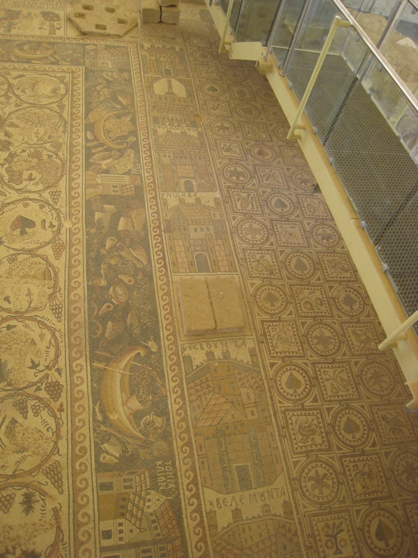
The highlight of the site is the Church of Saint Stephen, built around 785, well into the Islamic period. (It seems, though, that the Christian community's fortunes took a turn for the worse soon after this church was built.) The church features the largest perfectly preserved mosaic floor and is second in fame only to the Mabada Map. It features 15 cities of the Holy Land, both east and west of the Jordan, in bands running the length of the nave, as you can see in the photo above and the two photos below.

Here you can see the altar area of a smaller church from 587, known as the Church of Bishop Sergius, because of an inscription in the mosaic floor. St. Stephen's partially overlaid it. It seemed to me that it was probably incorporated as a side chapel.

For more photos from this day, click here.

Wednesday, November 16, 2011

Christ's Baptismal Site

Later that day, we headed to the Jordan River, where Christ was baptized by St. John the Baptist. Above is a shot of the river as it is today. The river is a source of life and rich green vegetation in the midst of arid desert. At the time of Christ, it was 1 km wide. In the last 50 years, due to Israeli water diversion, the river has shrunk to just 3 meters at point.

Due to water diversion, the river has shifted 300 meters to the west of its location at the time of Christ. Since the river marks the border between Israel (or Israeli-occupied Palestine) and Jordan, that means that the actual site where Christ was baptized is now 300 meters inside the Jordanian border. No serious scholars dispute that the site in the photo below is where Christ was baptized, as evidenced by the churches and baptisteries built on that spot from the earliest centuries. Above is a mosaic reconstruction of the site from around the 4th century. Below, you can see that the steps lead into a cruciform-shaped baptistery (originally in the Jordan River), where Christians could be baptized on the same spot Christ was, where the Holy Spirit descended on Him, and where the voice of God declared him to be His Son.

Next to the site, this sign indicates that the Greek Orthodox Patriarchate of Jerusalem intends to build a church dedicated to St. Mary of Egypt on this spot. The icon on the sign depicts St. Mary of Egypt receiving communion from St. Zosimus on the banks of the Jordan.

The Jordanian flag next to a fenced section along the Israeli-Jordanian border.

Right on the river, the Greek Orthodox Patriarchate of Jerusalem has a newly built church dedicated to the Theophany.

Here is my dad at the Jordan River, 300 meters due west from the original baptismal site. As you can see, the river is now quite small. On the opposite side, you see Christian pilgrims over in Israel preparing for some kind of baptismal ritual. As you can see, there is a walled/fenced enclosure into the water where the Christians can perform their baptism. In stark contrast to the Jordanian side, the Israeli side is quite built up. The Jordan side, on the other hand, has some rickety wooden benches and wooden overhang for protection from the sun. Pilgrims are free to do whatever they like at the water, without the permits necessary on the Israeli side.

A shot of the Jordan River, with an Orthodox church sticking up in the distance.

There are currently no active Orthodox monasteries in Jordan, but this one, just a few hundred meters from the river and dedicated to St. John the Baptist, is now being constructed.

For more photos, click here.

Monday, November 14, 2011

Madaba and Mt. Nebo


View Larger Map

On Sunday morning, we headed southwest from Amman to Madaba, which has been a Christian center for centuries and still features a large Christian enclave of about 15,000, approximately 8,000 of which are Orthodox.

We attended church at St. George's, which is the home of the famous Mosaic Map. The head priest was a Jordanian who had spent 9 years in the US serving an Antiochian parish in the Midwest, so he was happy to invite me to serve with them.

One of the deacon's doors to the altar had this interesting feature so that people could hand over their prosphora without opening the door all the way.

ROCOR Bishop Agapit (Gorachek) of Stuttgart was also with us in the altar, but did not serve. Afterwards, we headed to the parish center where we all had coffee with some of the parishioners. Christians make up about 5% of Jordan's population and, by all accounts, are very well treated both by the people and the government. Fr. Nicholas, the head priest, mentioned to me that the parish celebrates Divine Liturgy every Friday and often times it is better attended than the Sunday Liturgy, simply because weekends in the Muslim world are on Friday-Saturday, with Sunday the first day of the work week. Some Christian businesses are able to have Saturday-Sunday as their weekends, but Christians who work for Muslims don't always have that option for practical reasons.

Above is a close-up of a section of the 6th century map, which is really quite impressive. Madaba was a stopping point on Christian pilgrimages to the Holy Land, and the map was actually just as functional as it was decorative, indicating for pilgrims the holy sites and where they were located, with a surprising degree of accuracy, as contemporary research has shown.

I found it fascinating that, as famous as this map is and as many tourists as it draws, the church is still, first and foremost, a place of prayer, not a museum. Thus, during services, a carpet is rolled over the mosaics and we made the entrances right on top of the famous floor. As soon as the Liturgy is over, the carpet is rolled up, ropes are erected, and the church is opened to tourists.

After church, we headed to Mt. Nebo, the mountain just to the east of the Jordan and the Dead Sea. This is where Moses looked out over the Promised Land before dying and being buried somewhere nearby. Above is a photo of a round stone that was used as the gate to an early Byzantine monastery on this location. The stone, probably much like the one used to close Jesus' tomb, was rolled in front of the entranceway. In the background, you can also see a tree with many ribbons tied to it. This is done by Muslims and Christians alike as a sort of tama.

Above and below, some of the incredible views over the Promised Land that Moses also saw. The photo above includes a map from the site which indicates the direction and distances to important sites.

After Mt. Nebo, we made our way to the somewhat obscure site of the 6th century Church of the Holy Martyrs Lot and Procopius. The ruins and its beautiful mosaic floor are covered by what appears from the outside to be a small, modern house with no identifying signs. We were thus quite unsure if we had come to the right place. We roused a dozing man in a nearby shack and it turned out he was the site's manager. Not only that, but his family had actually lived in a house that stood on top of these ruins, although quite unaware of them until 1932, when his mother accidentally spilled milk down the old wood stove that stood in the middle of the house. She moved the stove in order to clean down into the floor and soon hit a mosaic tile. It was thus that the ruins of the church and the beautiful floor were found underneath 60 cm of accumulated earth. In the middle of the floor, near the altar, in the photo above, you can see a black spot. This is where their wood stove had stood all those years.

As you can tell, there are countless, beautiful mosaic floors from the Byzantine churches of the 5th-7th centuries in this region east of the Jordan. Interestingly, many if not most of the subject matter was taken from classical pagan art, which was enjoying a revival in the general (not specifically ecclesiastical) culture of that time, and it was melded also into the ecclesiastical art, which sought to adorn its churches with the greatest amount of beauty. Of course, there were also some biblical themes as well, and even some of the pagan subject matter was reinterpreted in a Christian light, such that, for example, it reflected the Christian eschatological vision.

Here's a photo of my dad with the man whose family had lived 60 cm on top of these ruins for generations.

For more photos, click here.

Monday, November 07, 2011

Gerasa

After Ajloun, we headed down to Gerasa (modern day Jerash), one of the best preserved Roman cities today. Gerasa, like Gadara, was one of the cities of the Decapolis. Sts. Mark and Luke record that Jesus' sending of the demons into the swine took place in the region of the Gerasenes, while St. Matthew, as we quoted in the last post, identifies it as the region of the Gadarenes. Gerasa was by far the larger city and the whole region, including up to Gadara, was known as the region of Gerasa. St. Matthew, who seems to be the most familiar with the biblical geography, was simply more precise in his description.

Gerasa features the best preserved Roman hippodrome in the world, which also happens to be one of the smallest, seating about 10,000-15,000 spectators. (The Circus Maximus in Rome, by comparison, seated about 150,000.) Above is my dad standing on the track.

They also offer a daily show that recreates some of what a Roman spectator would have seen at the hippodrome. The show is quite well researched by classicists and involves the man who worked as the technical advisor for the movie Gladiator. A large part of the show involved various drills by a Roman military detachment (see above). It also included a mock gladiator contest.

It ended with the chariot race.

Above, the huge Oval Plaza. The circle you see in the photo was actually a manhole that led the city's underground sewer system.

Above were the legs of a butcher's table in the forum. Each leg depicts an animal, including (if I remember correctly, a cow, a pig, and somewhat strangely, a lion).

The city was fully Christian in Byzantine times (ca. 350-650), with over 13 churches. Above are the remains of a large cross-shaped baptistery.

Above, my dad in front of the Nymphaeum.

Above is a photo we took of ourselves inside the enormous Temple of Artemis: "The Temple of Artemis was built in the 2nd century A.D. The columns are 12 m high and each drum weighs 20-40 tons. Artemis was the virgin goddess of nature and the hunt (the Romans called her Diana). The daughter of Zeus and the twin sister of Apollo, Artemis was one of the most popular Greek deities. She was like “Mother Nature,” life-giving and supportive on the one hand, but cruel and destructive on another. Artemis was also the patron goddess of a temple at Ephesus, whose well-being was threatened by the presence of the Gospel (Acts 19)."

A view from the highest part of the Temple of Artemis back toward the entrance to the temple. The square area at the bottom of the photo appears to have been an area for sacrifice.

This is a photo of the mosaic floor of one of the 13 churches built between 350-650 .

After this long day of sightseeing, we headed back to Amman, where we had a fantastic supper of hummus and falafel at a local joint, followed by some sweets at this place.

For more photos of this first day, click here.

Saturday, November 05, 2011

Pilgrimage to Jordan: Gadara and Ajloun

A couple weeks ago, I was blessed to be able to make a pilgrimage with my father to Jordan, a continuation of our pilgrimage to Jerusalem almost two years ago. We arrived rather late on Friday day and went straight to our hotel in Amman. On our first day, we headed to Gadara, on a hill on the east side of the Sea of Galilee, where Christ met the two demoniacs and cast them into a herd of swine, which ran down the hill into the sea.

Above is a photo of my dad exploring the ancient theater of Gadara, which was one of the cities of the Greco-Roman Decapolis. It was an important city of Byzantium until it was captured by the Muslims following the nearby Battle of Yarmouk in 636, one of the most important battles in history. Gadara was destroyed by an earthquake in 747 and abandoned.

Above, some of the ruins of the city.

Gadara's ruins are somewhat limited, but the view more than makes up for it. We stopped and had a coffee at a restaurant inside the site, from which we could sit and survey the Sea of Galilee (only 6 miles away). We could even make out the city of Tiberias in Israeli-controlled Palestine on the western shore of the sea, which you can see above and to the left of my dad in the photo above.

Besides the border with Israel only 6 miles away, we were even closer to the border with Syria or, more precisely, the Israeli-controlled Golan Heights, which you can see to the right of my dad in the photo above.

Above and below, shots of Gadara's main street.

After Gadara, we headed south to Aljoun, the site of a Muslim castle built by a nephew of Saladin in the late 12th century to defend against the Crusaders.

Here's a photo of my dad walking up the initial stairs into the castle.

Here's my dad looking out onto the modern city of Ajloun from the castle's walls.

For more photos from our first day in Jordan, click here.

Stay tuned for entries about the rest of our pilgrimage.